Defining Aerial Safari
Private helicopter travel in Australia transcends simple point-to-point transport; it is a strategic tool for environmental immersion. In regions like the Kimberley or the South Australian salt lakes, ground temperatures can exceed 40°C, and "roads" often consist of corrugated dirt tracks that limit travel to 20 km/h. A helicopter converts a grueling three-day drive into a 90-minute scenic transition.
In practice, this means landing on the pinnacle of a sandstone massif in Purnululu National Park for a sunrise breakfast, a feat impossible via traditional tourism. Operators like Nautilus Aviation or Microflite utilize Airbus H125 or H130 helicopters, known for their high-altitude performance and wide-view windows, ensuring that the visual data—be it the scale of the Great Barrier Reef or the geometric patterns of Lake Eyre—is captured without distortion.
Statistically, private aviation in the Australian tourism sector has seen a 22% increase in demand since 2022. Travelers are increasingly prioritizing "isolation luxury," where the value is found in the absence of other people. Data shows that a dedicated charter can cover 500 nautical miles in a single day, visiting four distinct ecosystems that would otherwise require two weeks of terrestrial travel.
Common Logistics Errors
The primary failure in planning aerial tours is underestimating the "ferry time"—the cost and time it takes for an aircraft to fly from its base to the pickup point. Many travelers book remote lodges without realizing the nearest heli-base is 300 kilometers away, leading to unexpected positioning fees that can exceed $5,000 AUD before the actual tour begins.
Ignoring seasonal "Burn-Offs" and the "Wet Season" is another critical oversight. In Northern Australia, smoke from controlled bushfire preventative burns between May and July can drastically reduce visibility, turning a scenic flight into a hazy disappointment. Conversely, during the monsoon (December–March), sudden cell storms can ground flights for days, trapping travelers in remote camps.
The consequences of poor planning manifest as "rushed itineraries." Trying to see the 12 Apostles, the Barossa Valley, and Uluru in a five-day window via air ignores the physiological fatigue of vibration and noise. Real-world scenarios often involve passengers arriving at a bucket-list site like the Horizontal Falls only to find the tide is "neap" (stationary), rendering the aerial view static because the flight wasn't timed with the lunar cycle.
Precision Planning Tips
Selecting the Right Airframe
The choice between a Robinson R44 and an Airbus H130 is not just about price; it’s about payload and stability. For professional photographers, the R44 allows for "doors-off" operations more easily, but for groups of four or more, the H130’s theater-style seating ensures no one is stuck in a middle seat with limited views. Always verify the maximum takeoff weight (MTOW) if carrying heavy camera gear or luxury supplies.
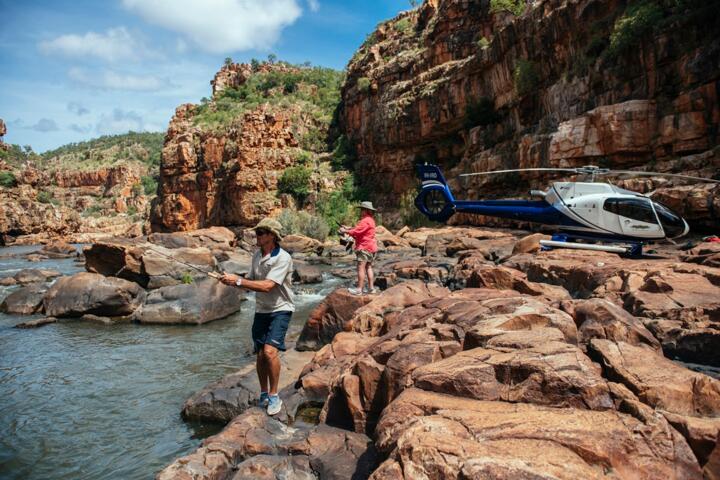
Timing the Kimberley Tides
When visiting the Buccaneer Archipelago, consult the Australian Bureau of Meteorology (BOM) tide charts. The Horizontal Falls are best viewed when the tidal range exceeds 8 meters. Booking a charter with a pilot who understands "slack water" vs. "peak flow" ensures you see the white-water rush through the gaps, rather than a calm pool. This level of detail separates a standard tour from an expert expedition.
The Lake Eyre Inflow Cycle
Kati Thanda–Lake Eyre is usually a dry salt pan. However, every few years, floodwaters from Queensland travel down the Cooper Creek. Experts monitor the "inflow" status via the Lake Eyre Yacht Club reports. Flying when the water coverage is at 30-50% creates a mirror effect that is visually superior to a fully flooded lake. Use operators based in William Creek for the lowest ferry costs.
Arnhem Land Cultural Access
To fly over and land in Arnhem Land, you need more than just a flight plan; you need a permit from the Northern Land Council. Partner with companies like Venture North that have long-standing relationships with Traditional Owners. This allows for landings at "rock art" sites that are not open to the general public, providing an ethnographic depth to the geological tour.
Managing the Heat Soak
In the Red Centre (Uluru/Kata Tjuta), air density drops as temperature rises, which can limit helicopter lift capacity. Schedule all "deep desert" flights for the first two hours after sunrise. Not only is the light better for shadows on the monoliths, but the aircraft performs more efficiently in the cooler, denser air, allowing for more fuel and longer loiter times over the Olgas.
Aerial Expedition Cases
Case One: A European media production team needed to document the "Wild Rivers" of the Gulf Country in 48 hours. Using a twin-engine Bell 429 based out of Cairns, the team bypassed flooded road networks that had stranded all ground vehicles. By utilizing satellite fuel drops previously arranged by the operator, they covered 1,200 km, capturing 8K footage of the "Morning Glory" cloud formation. The result was a 40% reduction in production time compared to fixed-wing/ground hybrid models.
Case Two: A private family group aimed to see the "Pink Lakes" of Western Australia (Hutt Lagoon) and the Abrolhos Islands in one day. The challenge was the 25-knot coastal winds typical of the region. By selecting a heavy-duty Leonardo AW139, the pilot maintained a stable platform for photography despite the gusts. They landed on a private island for a seafood lunch sourced directly from local lobster pots, a logistics feat that ground-based luxury travel could not replicate.
Aircraft and Region Guide
| Region | Recommended Aircraft | Best Month | Primary Visual Highlight |
|---|---|---|---|
| The Kimberley, WA | Airbus H125 (Squirel) | May - August | Merrick’s Falls & Bungle Bungles |
| Great Barrier Reef, QLD | Airbus H130 | September - Nov | Heart Reef & Outer Ribbon Reefs |
| Red Centre, NT | Bell 206 Jetranger | June - August | Kata Tjuta (The Olgas) shadows |
| Tasmanian Wilderness | Airbus H125 | January - March | Bathurst Harbour & Port Davey |
| South Aus Salt Lakes | Cessna 208 (Caravan) | Variable (Post-Rain) | Lake Eyre water reflections |
Avoiding Pitfalls
Never book a "scenic flight" without asking for the specific tail number of the aircraft. Some brokers advertise high-end helicopters but substitute them with older, vibratory models at the last minute. Ensure your contract specifies a "guaranteed window seat" or a "private charter" to avoid being grouped with strangers who might obstruct your camera angles.
Avoid "Midday Dead-Light." Flying between 11:00 AM and 2:00 PM flattens the landscape. The iron-rich reds of the Pilbara and the deep greens of the Daintree Rainforest require the low-angle sun of the "Golden Hour" to reveal texture. If an operator pushes for a noon flight, it’s usually for their own scheduling convenience, not your visual experience.
Communication failure is the third pitfall. Ensure the helicopter is equipped with noise-canceling Bose or David Clark headsets with an "intercom override" function. This allows the pilot to provide expert commentary on the geology and indigenous history without you having to scream over the engine noise, turning a flight into an educational seminar.
FAQ
What is the weight limit for remote helicopter tours?
Most light helicopters have a per-seat limit of 110-130kg. In Australia, CASA (Civil Aviation Safety Authority) regulations require accurate weighing of all passengers and luggage before departure. Exceeding these limits often requires upgrading to a larger, more expensive aircraft class.
Can we land anywhere in the National Parks?
No. Helicopter landings are strictly regulated. You can only land at designated helipads or on private property with the owner’s written permission. Expert operators have pre-arranged "concessions" to land in remote spots that are off-limits to standard charters.
How does the weather affect my booking?
Safety is paramount. If a flight is canceled due to low cloud ceilings or high winds, reputable operators like Helicopter Group or GBR Helicopters will offer a reschedule or a full refund. Always build a "buffer day" into your itinerary for remote regions.
Is doors-off photography worth the extra cost?
For professional-grade photography, yes. It eliminates glass reflections and allows for vertical "top-down" shots. However, it is significantly colder and noisier, and all loose items must be tethered to your person with lanyard systems.
What should I pack for a remote desert landing?
Even if the flight is air-conditioned, a landing in the Tanami or Gibson deserts requires high-SPF sunscreen, a wide-brimmed hat with a chin strap (to prevent it being sucked into the rotor wash), and closed-toe boots. The ground can be 15 degrees hotter than the air.
Author’s Insight
In my fifteen years of navigating the Australian airspace, I’ve learned that the most expensive flight is the one where you didn't see what you came for because of 15 minutes of bad timing. I always tell my clients: don't just buy flight time, buy the pilot's local knowledge. A pilot who grew up in the Ord River Valley knows exactly which hidden waterfall flows only after a specific rainfall. My top advice is to always ask for a "pre-flight briefing" the night before to check the latest satellite moisture maps; it can be the difference between seeing a dry creek bed and a thundering cataract.
Summary
Executing a private helicopter tour across Australia’s wild landscapes requires a synergy of meteorological timing, aircraft selection, and local permitting. To maximize the value of an aerial expedition, prioritize early morning departures, verify specific airframe models to ensure optimal visibility, and account for ferry costs in the initial budget. The Australian outback is best understood from the air, where the true scale of its ancient geology becomes visible. For your next trip, move beyond the standard tourist routes and engage an operator that offers bespoke flight paths tailored to the current environmental conditions.